
The Geopolitical Realities of Eurasia
Anyone who glances at the Eurasian map and concludes that the countries that make up the continent came about due to the decisions of men or women is sadly mistaken. Although government actions are indeed at times a factor, the overriding force that forms nations, states, and empires in this region is geography. Anyone studying Eurasian politics should be aware of these geopolitical realities.

On Eurasia’s western end (Europe) there exists a collection of countries, while its eastern end is dominated by a single state: China. Eurasia’s northern swathe is controlled exclusively by Russia, while its south is divided amongst a number of countries. These are the realities of the Eurasian map; they do not come about because of mere chance, but are caused by geography. I will examine these realities.

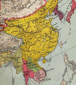
Geopolitical Eurasia of 1897 (left)
Europe consists of a multitude of states while China consists of one
 Looking at the Eurasian map, does it not appear peculiar that while the West consists of so many states that none dominate the region, the East is clearly dominated by a single state? This phenomenon has existed throughout history. Since 221 BC, China has been a single unified nation. China has occasionally disintegrated during ‘warring states’ periods, but generally a single dynasty has always maintained control of the area. This fact is due to geography. Meanwhile in Europe, no single state has ever dominated the entire continent – at one point Rome may have come close, but this remains the exception. The continent resisted the aspirations of Charlemagne, Napoleon, and Hitler. This fact is again due to geography.

The Roman Empire at its height, 117AD
Europe has a highly indented coastline. It has five large peninsulas, all of which evolved independent people, languages, and subsequent governments. These peninsulas are Norway/Sweden, Denmark, Portugal/Spain, Italy, and Greece. Europe also has two major islands, Britain and Ireland. Europe is further carved up by a series of mountain ranges, the Alps, Pyrenees, Carpathians, and the Norwegian Border Mountains. Finally Europe’s two major rivers, the Rhine and the Danube, serve as borders to further divide the continent. The division of Europe by geography served to develop a multitude of ethnic groups, governments, and states. Such is Europe’s division that its nations have historically been in a state of near-constant war, be it between the Athenians and the Spartans, or between the Prussians, Habsburgs, and Ottomans, or between the British, French, Germans, and Russians. Today Europe’s peoples bicker over economics and are less unified than many would have us believe.
The Ming Dynasty at its height, 1402 – 1424
China, on the other hand, has a much smoother coastline. Only the Korean peninsula and the peninsula of South-East Asia are sufficiently separated to allow for the formation of separate nations. China’s two largest islands, Taiwan and Hainan, are each less than half the size of Ireland. Japan is the only island to be large enough to form a separate state. China’s only mountain range (the Himalayas) separates it from India rather than separating its people. China’s heartland is bound together by two long navigable rivers, the Yellow and Yangtze Rivers. North and South China are bound together by a relatively easy connection between these two rivers that was later linked by the Grand Canal. Europe’s two major rivers are much smaller, and connect much less of the continent, and thus do not serve as the unifiers that China’s rivers do. What appears as peculiar at first is really quite simply a result of geography.
The Northern swathe will always be dominated by a single aggressive nation
 The Russia political elite have historically always believed they must defend Russia from influence and invasion by securing its frontiers. This foreign policy paradigm is traceable to the thirteenth century, when Russia was smashed by the Mongols who rampaged across Eurasia, and was denied access to the European Renaissance. Russia was thus branded with bitter feelings of inferiority and insecurity. To maintain its security, Russia must conquer as much territory as it can. Kaplan argues throughout Russia’s history, it has acted as “a land power that had to keep attacking and exploring in all directions or itself be vanquished.” We see this in the 1800s when Russia pushed into Eastern Europe in an attempt to block France, and again in 1945 when Moscow used Eastern Europe as a buffer-zone against a resurgent Germany. Russia has also pushed into Afghanistan to block the British during the Great Game, and conquered the Far East to block China. These same motives were at play when the Soviets invaded Afghanistan in 1979. Moscow again felt vulnerable when the Soviet Union dissolved and it lost the buffer-zone it gained in 1945. This is why today Putin believes the European Union is a threat, and why the Kremlin attempts to bring Eastern European countries back into its sphere of influence, and why it invaded Georgia in 2008. My article The Wiley Bear – Russian Motives for the Nord Stream Pipeline analyses this phenomenon in relation to pipeline politics.

The Central Asian Steppe
Only analysing Russia’s paradigm today ignores the fact that throughout history any nation that controls Eurasia’s North acts in this way. Just as the Mongols devastated medieval Europe, the Huns sacked Rome, and the Scythians raided from the east before that. The Great Wall of China was built to defend against steppe raiders. Each of these nations aggressively secured their frontiers in a similar manner to that of Russia in the last century. This fact is caused entirely by geography. From the Hungarian plain, through Ukraine, the northern Caucasus, and Central Asia to Manchuria of the Far East lays the Central Asian steppe, the world’s vastest grassland. It was called “the great grass road” by Russian scholar W. Bruce Lincoln. Any peoples who reside on this steppe are inevitably insecure, because they have no natural defenses such as mountains or forest. They must conquer or be conquered. After the High Middle Ages, Russia became the single nation to dominate this region, but this region has always been dominated by a single nation, be it the Mongols, the Huns, or the Scythians, and this fact is due to geography.
The Middle East and Southern Asia: again a multitude of states
 Because of geography a single state dominates Eurasia’s north. It is also because of geography that Eurasia’s south is divided. Like in Europe, no single nation has dominated this region. Although the Persian Empire of 500 BC, Alexander the Great, and the Ottoman Empire have each come extremely close, these remain exceptions to the rule.
Geography defines the Middle East’s borders. The borders of Iran are defined by the Iranian plateau while the borders of Turkey are defined by the Anatolian land bridge. The Arabian Peninsula is dominated by Saudi Arabia. Yemen exists at this peninsula’s south because this area is characterised by mountains and a network of oases.

The Persian Empire of 500BC (left) and Ottoman Empire of 1801
India too is defined by geography. It is a peninsula framed by the Arabian Sea on its west, and the Bay of Bengal on its east. The mountainous Burmese jungles separate it from the nations of South-East Asia, while the Himalayas separate it from Tibet. But geography has also left India vulnerable to attack from the northeast. India is bordered by the Persian-Afghan plateau, which consists of a gradual incline rather than a divisive mountain range. India is thus dangerously close to the Central Asian steppe. It is from here that India has faced invading Greeks, Persians, and Mongols. The British Empire felt most vulnerable at this frontier during the Great Game, and it is here that India faces its rival Pakistan today. I outlined this last fact when I argued India is ‘cursed by geography’ in my article The Era of the Eagle – American Hegemony is Here to Stay. But while India is indeed defined by geography, it is also divided by it. India does not have the same unifying rivers that China does. Its multitude of river systems (be it the Ganges, Brahmaputra, Narmada, Tungabhadra, Godavari etc.) only divide the region. Its weak borders mean other nations such as Nepal, Pakistan, and Bangladesh exist on the Indian subcontinent. These non-unifying factors mean historically India has been made up of many polities, and more recently a Hindu-Muslim drama has occurred.
Woks Cited
Diamond, Jared. Guns, Germs, and Steel. New York: W.W. Norton and Company, 1999.
Kaplan, Robert D. The Revenge of Geography. New York: Random House, 2012.

A really well argued piece. I had not considered many of the reasons you’ve touched upon but having read it they all seem so clear and obvious. A good read!
Thankyou, I hadn’t realised how fundamental geography was to nation-forming either until recently.
I think it was Halford Mackinder who said that a knowledge of rivers should form the grammar of global strategy. I had always thought of rivers as unifying factors. Your article brings out nicely their divisive role. Very interesting analysis.
That sounds right, Kaplan’s book (which I cited for this piece) refers to Mackinder extensively, the so-called founder of geopolitics and geostrategy.